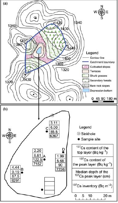
Figure Present land use condition, the location of the cores sampled and 137Cs characteristics of the cores in the Shirenzhai catchment. (a) Present land use conditions; (b) location of sampling cores and 137Cs characteristics of the cores.
Deforestation to reclaim land often triggers severe soil erosion in the Guizhou Karst Plateau. Cs-137 dating of the deposited sediments in the karst depression bottom was used to estimate soil losses by surface erosion since deforestation started in 1979 on hillslopes in the Shirenzhai catchment, Puding County, Guizhou Province. The catchment has a drainage area of 0.054 km(2). The average Cs-137 contents of the top and peak layers in five cores of the depression bottom (with an area of 2652 m(2)), collected in 2009, were 2.35 and 7.25 Bq kg(-1), respectively. The medium depths in the depression (which ranged between 84 cm and 113.5 cm with a mean value of 92.1 cm) showed the presence of sediments deposited in 1979. The total volume and weight of the deposited sediments since 1979 were estimated to be 1965 m(3) and 2496 t, respectively. The depression bottom can be treated as a temporary impoundment and its sediment trapping efficiency was estimated to be 0.7. The relevant average soil erosion rate on the hillslopes was 2315 t km(-2) yr(-1) since 1979. The mean Cs-137 inventory of the five cores was 7693 Bq m(-2), which was similar to 10 times the local reference inventory of 782 Bq m(-2). The total Cs-137 activity of the sediments in the bottom was 20.4x10(6) Bq, and the relevant Cs-137 inventory loss from the hillslopes was 358 Bq m(-2) (since 1954), which accounted for 45.8% of the reference inventory. As soil erosion was not severe before and after the period of deforestation and following cultivation in 1979-1990, the erosion rates on the hillslopes could potentially reach 7000 t km(-2) yr(-1).
| Publication name |
SCIENCE CHINA-EARTH SCIENCES Volume: 54 Issue: 3 Pages: 431-437 Published: MAR 2011 |
| Author(s) |
Zhang XinBao; Bai XiaoYong; Liu XiuMing |
| Corresponding author |
Bai XiaoYong
baixiaoyong@126.com
1. Chinese Acad Sci, Inst Mt Hazards & Environm, Key Lab Mt Environm Evolvement & Regulat, Chengdu 610041, Peoples R China
2. Chinese Acad Sci, Grad Sch, Beijing 100049, Peoples R China |
| Author(s) from IGCAS |
ZHANG XinBao; LIU XiuMing |